| URLs in this document have been updated. Links enclosed in {curly brackets} have been changed. If a replacement link was located, the new URL was added and the link is active; if a new site could not be identified, the broken link was removed. |
![]()
Creating a Geo-Referenced Bibliography with Google Earth and GeoCommons: the Coos Bay Bibliography
Jenni Schmitt
Library Assistant
jenni_schmitt@hotmail.com
Barb Butler
Librarian
butler@uoregon.edu
Loyd and Dorothy Rippey Library
Oregon Institute of Marine Biology
University of Oregon
Charleston, Oregon
Introduction
We compiled a geo-referenced bibliography of research including theses, peer-reviewed articles, agency literature, and books having sample collection sites in and around Coos Bay, Oregon. Using Google Earth and GeoCommons we created a map that allows users such as visiting researchers, faculty, students, and local agencies to identify previous research conducted in their location of interest. There are links to specific citations and, if available, full-text documents. The interactive map allows users to zoom and filter for specific layers of interest. The bibliography was created and is maintained in EndNote, but a searchable PDF version resides in our institutional repository (Butler and Schmitt 2012).
Why Coos Bay?
Coos Bay is the second largest bay on the Oregon coast, consisting of 11 tidal inlets. It is an important port for the logging and fishing industries in southern Oregon. In the 1920s it was chosen as the site for University of Oregon's Institute of Marine Biology (OIMB) for the variety of nearby habitats: estuarine channels within the bay; high-energy sandy beaches to the north; and rocky intertidal to the south. Numerous state and federal agencies, universities and nonprofit organizations have conducted research here allowing us to provide a comprehensive bibliography and search tool for future researchers.
Why GeoCommons?
It is possible to create spatial or geo-referenced bibliographies using open source software such as Google Earth or GeoNetwork (GeoNetwork Opensource 2012; USGS 2012), or Geographic Information System (GIS) software such as ArcGIS. Examples of spatial bibliographies using GIS software are the Global Database of Soil Respiration Data (Bond-Lamberty and Thomson 2010), Leishmaniasis E-Compendium (Hendrickx et al. 2010), Northwestern Hawaiian Islands Spatial Bibliography (Taylor and Nelson 2006), and the Papahanaumokuakea Marine National Monument Spatial Bibliography (Papahanaumokuakea Information Management System). It is also possible to use ARC to geospatially enable MARC bibliographic records (Haas et al. 2003). However, these options require creators to host the resource or learn a complicated GIS software program. Google Earth Community allows online posting, but the final map isn't easily updated. Another example of a spatial bibliography is the CD version of the Lower Arkansas River Alluvial Aquifer (Watterson and Topper 2007), but because it is a static resource it will become outdated over time. An interesting database on Cutthroat Trout (Geo-referenced Database for Coastal Cutthroat Trout) is now a broken link. Another comprehensive coastal resource, the Yaquina Bay Bibliography (Webster and Hiveley 2006), is now only available as a text file. Clearly, if an online spatial bibliography is going to remain relevant and viable it must be easy to maintain.
The combined Google Earth/GeoCommons technique we describe below allowed us to create a visual interface which is searchable and available on a user-friendly platform. We won't have to buy or learn a GIS software package and we can host our updateable project in the cloud.
Methods
Literature having research collection sites within the Coos Bay watershed and adjacent coastline has been compiled into an EndNote bibliography. We used the latitude/longitude, maps, or detailed written descriptions of study locations within the methods sections of the citations to geo-reference the sample site using Google Earth. Because some studies involved multiple sample sites there were nearly 1,500 icons for the 430 items in the bibliography. References lacking specific sample site descriptions were given an icon over the OIMB campus. Google Earth was used because it is user-friendly with a quick learning curve, allowing any employee to easily create new entries during quarterly updates.
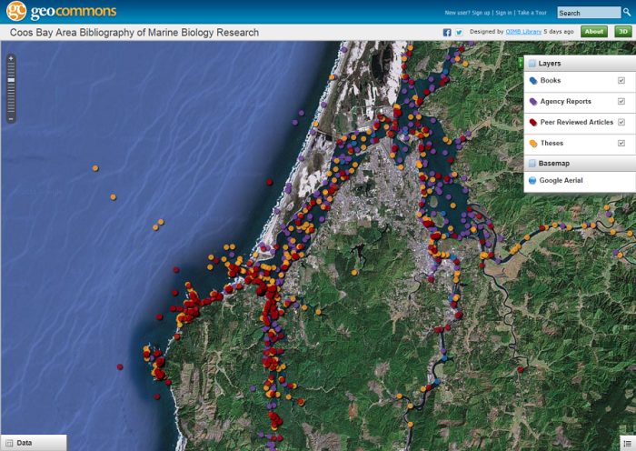
Geo-referenced citations from the Google Earth map were converted from KML to a CSV Excel� file for importation into GeoCommons. GeoCommons datasets were then compiled into a single map with layers for "Theses", "Peer Reviewed Articles", "Books", and "Agency Reports." This map was published online as: {http://geocommons.com/maps/204831}
Figure 1: Partial screenshot of the Coos Bay Area Bibliography of Marine Biology Research as seen on GeoCommons.
Where to from here?
Future plans for the Coos Bay Area Bibliography will be the addition of "Collection Site" and "Water Quality Data Set" layers, making our GeoCommons map into an information portal for researchers. The "Collection Site" layer will be an especially useful aid for visiting students and faculty interested in collection locations for specific organisms. Data for this layer will have scientific and common names of species and photo links from the Oregon Institute of Marine Biology Slides & Photographs collection. The "Water Quality Data Set" layer is a compilation from the Coos Watershed Association and contains links to water quality data websites, much of the data real-time and available for download. Icons for this layer will contain metadata on collection parameters, responsible agency, sampling frequency and collection dates.
Conclusion
Search engines and databases are the best tools for accessing literature, but there are situations where a comprehensive list of geo-referenced resources will be of use to the research community. Some bibliographies will contain too many citations to examine individually as we did for this project and may best be delivered as a searchable database such as the Galveston Bay Bibliography (Galveston Bay Information Center 1997) or as a printed resource with updates such as the Monterey Bay Bibliography (Baron 1971). Those with moderately large bibliographies on a focused geographic region may be able to make use of this methodology to easily create a spatial bibliography. We invested nearly 200 hours to update our EndNote bibliography and create the Coos Bay resource described above. Reviewing the methods section of each item was the most time-consuming part of the process. We believe the Google Earth/GeoCommons two-step process to create a geo-referenced bibliography is easier than other examples seen to date and will be simple to maintain.
References
Baron, Doris. 1971. Monterey Bay bibliography; a partial, provisional bibliography of scientific and general papers, reports, books, and miscellaneous publications which deal directly or indirectly with the central California coast. Moss Landing (CA): Moss Landing Marine Laboratories.
Bond-Lamberty, B. and Thomson A. 2010. A global database of soil respiration data. Biogeosciences 7:1915-1926. Database available from: http://code.google.com/p/srdb/.
Butler, B. and Schmitt, J. Coos Bay Bibliography. [Updated 2012 Oct 17]. [Internet]. Available from: http://hdl.handle.net/1794/12309
GeoNetwork Opensouce. 2012. [Internet]. [Updated 2012 Apr 5]. Open Source Geospatial Foundation. Available from: http://geonetwork-opensource.org/
Geo-referenced database for coastal cutthroat trout Oncorhynchus clarki clarki of Washington and Oregon. 2012. [Internet]. [Accessed 2012 Oct 22]. Available from: {ttp://ocid.nacse.org/nbii/cutbib/index.php}
Galveston Bay Information Center, Galveston Bay Collection. 1997. Galveston Bay bibliography. [Galveston, Tex.]: Galveston Bay Information Center. Available from: http://www.tamug.edu/gbic/gbb.html but requires a login.
Haas, S. et al. 2003. MARC and ARC: geospatially enabling bibliographic records. In: International Association of Aquatic and Marine Science Libraries and Information Centers. Conference Proceedings (28th: 2002: Mazatlan, Sinaloa, Mexico), pages 119-126. [Internet]. [Cited November 27, 2012]. Available from: http://hdl.handle.net/1912/692
Hendrickx, D. et al. 2010. The leishmaniasis e-compendium: a geo-referenced bibliographic tool. Trends in Parasitology 26(11): 515-516. Database available from: {http://dx.doi.org/10.1016/j.pt.2010.06.015}
Papahanaumokuakea Information Management System. Papahanaumokuakea Marine National Monument Spatial Bibliography. [Internet]. [Accessed 2012 Oct 22]. Available from: {http://www.pmnmims.org/SpatialBibliography/}
Taylor, C. and Nelson D.M. 2006. Northwestern Hawaiian Islands spatial bibliography: A science-planning tool. Atoll Research Bulletin 543:51-64.
USGS Coastal and Marine Geology Program. 2012. [Internet]. [Updated 2012 Aug 10]. United States Geological Survey. Available from: http://cmgds.marine.usgs.gov/gsearch.html
Watterson, N.A. and Topper, R. 2007. Lower Arkansas River Alluvial Aquifer: Geographic, Digital Bibliography. Denver, Colo: Colorado Geological Survey.
Webster, J. and Hiveley, H. 2006. Yaquina Bay Bibliography. Western Ecology Division of the United States Environmental Protection Agency Oregon Sea Grant Oregon State University Libraries, 239 pages. [Internet]. [Cited November 27, 2012]. Available from: http://hdl.handle.net/1957/8310
| Previous | Contents | Next |
