![[PREVIOUS]](../graphics/backward.gif)
![[CONTENTS]](../graphics/contents.gif)
![[NEXT]](../graphics/forward.gif)
|
|
|
|
| Issues in Science and Technology Librarianship | Summer 1997 |
|---|
| DOI:10.5062/F4ZP444N |
When we started to write this introduction with a brief description of playa lakes we found that for every statement we used to describe playas an opposite and equally true statement could be made. For example, generally, playas are small round features however, lake size can range from less than 1 KM2 to over 9000 KM 2 as in the case of Lake Eyre in central Australia. They tend to be shallow and ephemeral but, the Great Salt Lake in Utah is an example of a perennial playa lake. They may contain fresh water but many are saline, so much so that they yield appreciable quantities of evaporite minerals such as sodium chloride which make them commercially attractive.
A "Playa" is Not Always a Playa: International Terminology
The term playa was added to the eighth edition of the Library of Congress subject headings in 1975. According to Lynn El-Hoshy, Library of Congress Cataloging Policy and Support Office, the term "playas" was proposed as a subject heading with the "BT Lakes" (Broader Term) in June 1973. The form of heading was based on entries in Webster's third New International Dictionary, the 1972 subject index to Water Resources Abstracts, and the Water Resources Thesaurus. In June 1974, the "UF Playa Lakes" (Used For) was added to the heading. Since the heading was established, LC has applied it to only 19 works in its bibliographic database (El-Hoshy, 1997).
Despite extensive research around the world suggesting the need for greater accuracy and detail in the headings used to describe playa lakes, no changes have been made for over twenty years. Library of Congress subject headings only permit a finer classification based on geography. Yet a playa may be wet or dry, fresh or saline, large or small, natural or artificial (Figures 1 & 2). Thus, the term playa by itself is grossly inadequate to describe these wetland systems. As research continues to expand, there will be a corresponding growth in the need for a more precise vocabulary describing these depressional wetlands. International parallels as well as distinctions suggest the modification of the subject headings for playas into a hierarchical structure encompassing the many physical and biological variables encountered in the real world. Using the term playa to describe a depressional wetland is like calling every automobile on the road a car. Use of such generic terms is understandable informally, yet in the relatively precise language of science, such general references are at best inadequate and at worst confusing.
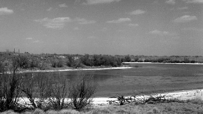
Figure 1: Rural saline playa, Upper Paul's Lake, West Texas.
Different regions of the world have their own word for playa, the Australians use the terms "pan" and "salt pan". In the Middle East a playa may be called a "sabkha" or a "qa". The South Americans use the term "salar" while "chotts" are found in Africa. Other terms that often appear in the literature are "salt flat", "alkali flat" and "salina". Although, in the literature, all these terms are used synonymously with the word playa they do not necessarily represent identical geological or biological settings. Therefore, it may be better to think of the word playa as a generic term for a variety of topographic depressions that occur in arid and semiarid climates (Neal, 1975).
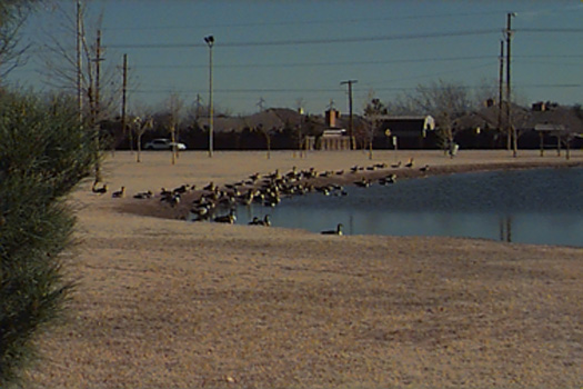 Figure 2: Urban freshwater playa, Jack Stevens Park, Lubbock, Texas.
Playa research is most active in North America and concentrated in the Southern High Plains of West Texas. Yet, just as depressional wetlands occur around the world, so too does the body of researchers studying these interesting ecosystems. Typically, these studies investigate physical systems such as chemistry, geology, soils, hydrology, and mineralogy. A handful of investigators have also probed the living systems of playa lakes with an emphasis on macrophytes and invertebrates. Much of the work in North America, in contrast, has involved vertebrates, primarily waterfowl. Biological studies have been done in Spain, South America, Australia, and Africa. Frequently, playas in these reports are saline lakes which again is very different from much of the work conducted in North America, which focuses on freshwater playas. In a study by Smith into Saharan playas, he found a number of superficial similarities between those playas and the playas of North America, but he found greater differences (Smith, 1970). This further suggests the need for reevaluating the use of the term "playa" in scientific research.
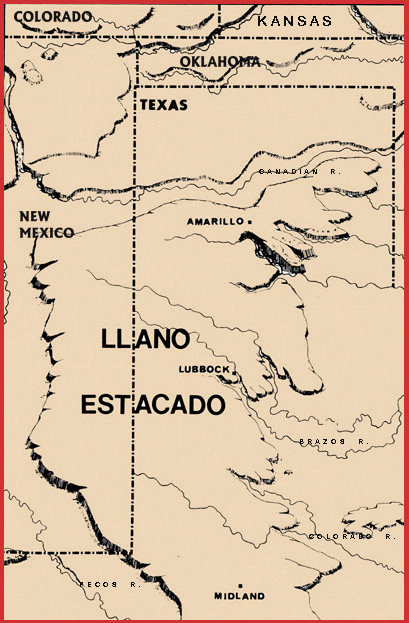 Figure 3: Map of the Llano Estacado.
Later, during the early 1800's the United States government sent expeditions to explore the territory but the first written reports sent back to Washington described the region as desolate with little water and uninhabitable. However, this was not true, the soldiers just didn't know where to look. The Comancheros had been using the playa lakes along their trade routes as a source of water for years. Then, in 1872 Col. Ranald Mackenzie, utilizing information furnished by a captured Camanchero, reported that the playas and rivers in this area furnished plenty of water, enough to sustain the natives already living in the region. It was soon after this that ranchers and farmers arrived on the South Plains utilizing the playas in their agricultural practices.
Since then playa lakes have continued to be a subject of scientific research. One of the earliest investigators was I.C. Russell, who in 1883 he wrote an article for Popular Science Monthly entitled "Playas and playa lakes". It was only six pages long but is one of the earliest published works on playa lakes. Russell continued his investigations, this time for the United States Geological Survey (USGS) and in 1885 wrote the "Geological history of Lake Lahontan, a Quaternary lake of northwestern Nevada". He pursued playa lake research with investigations for the USGS and continued to publish until the early 1900's. Another early investigator G.K. Gilbert also working for the USGS published "Lake Bonneville" in 1890. Nonetheless, further interest in playa research waned and publications appeared only sporadically over the next 60 years.
It wasn't until the 1960's that interest began to increase. Throughout the years that followed, the research became increasingly specialized and interdisciplinary. Papers presented at the 1970 and 1994 Playa Basin Symposiums at Texas Tech University illustrate the broad scope of current playa research. Some of the topics discussed were: playa basin origin, history, aquifer recharge, water quality, economic / environmental considerations, management, playa modification, wetlands and federal regulations. Research within these areas includes the work of geologists, soil scientists, hydrologists, range and wildlife biologists, agriculture scientists, and historians. Due to the trend of increasing regulations over wetlands, future symposia may also include lawyers.
Perhaps the most significant contribution to playa lake research has been made by geologist C.C. "Tex" Reeves, Ph.D. Reeves began studying playa lakes in 1958 when he was told they were formed by buffalo and he didn't quite believe it. His skepticism has led to the publication of seven books and countless articles. When asked to discuss the significance of his contribution to playa research Reeves replied, " When I started in playa research there, were no funds available, there was no interest, and there was very little data in the literature. In fact, local farmers (with the exception of a few dedicated investigators at local water districts) knew more about the host rocks (Ogallala section) than did local geologists. My early studies, resulting in the book Paleolimnology (1968), focused attention on the playas and lake basins of the Southern High Plains as well as those of other continents (Africa and Australia)."
Reeves expects that, from a geologic standpoint, future research will focus on: the refinement of dating techniques, further documentation of various genetic types, morphologic and depositional responses of the lakes to climatic changes, morphologic changes in playa lakes with time, factors controlling specific locations, the influence of regional structure, the relationship of incipient playa basins to large playa lakes, and the relationship of playa basins to large alkaline lake basins (Reeves, C.C., 1997).
In Reeves recent book, The Ogallala Aquifer of the Southern High Plains he estimates the number of playa lakes on the Llano Estacado between 17,000 and 37,000 with 40+ larger saline lakes (Reeves and Reeves, 1996). These playas sit on top of the southern portion of the Ogallala aquifer, one of the largest aquifers in the United States (Figure 4). Clearly with so many playas in this region, determination of infiltration rates (aquifer recharge) is crucial.
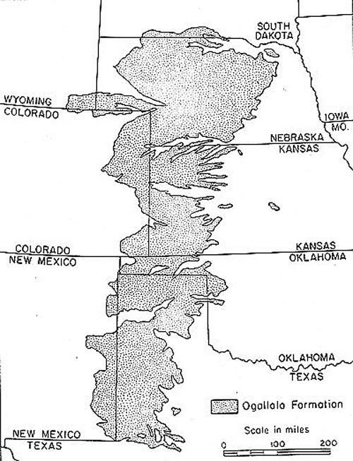 Figure 4: Map of the Ogallala Acquifer (Mattox and Miller 1970).
For years scientists have spent time and money trying to determine the rate of recharge from playa lakes into the underlying aquifer. With water being a valuable commodity in semi arid and arid regions, the rate of infiltration is a vital component in the overall groundwater budget. However, geologist Judy Reeves Ph.D., co-author of The Ogallala Aquifer of the Southern High Plains, feels this pursuit to determine a rate of recharge has been illusive at best. She believes that, "the future of playa lake research does not lie in the investigation of individual playas and that recharge values that are representative of a "type area" will come from comprehensive studies of the Ogallala aquifer that will combine all of the critical data that affects recharge on the Southern High Plains". J. Reeves has no doubt that the playas and the Ogallala aquifer are the most important geologic features on the Southern High Plains and feels that you can't investigate the one without investigating the other (Reeves, J., 1997). That is why the Ogallala and playas in this area of Texas are some of the most studied in the world.
David Houkos Ph.D. a wildlife biologist at Texas Tech, has worked on the applied side of playa research since 1989 when he began doctoral work on a management scheme to manipulate playa vegetation to enhance wildlife habitat (Haukos 1991). He describes playas as relatively simple systems, yet a fundamental understanding of their ecology is some twenty years behind similar systems such as the prairie potholes. For example, "managing the vegetation of these lakes for maximum benefit of wildlife has been worked out", he says, "but understanding such fundamental processes as nutrient cycling is essentially a mystery". This is atypical, since most natural systems are first studied for their basic ecological patterns then approached from the standpoint of applied research. There are a number of possible explanations for this reverse approach. One explanation is that basic ecological studies require a long term commitment which is difficult to make in light of how our present educational system is structured. Even though most playa systems operate on a very compressed seasonal cycle, it is important to examine the basic elements of these cycles over long periods of time to strengthen the conclusions from tested hypotheses (Haukos 1997).
While recognized by the earliest inhabitants and explorers of the region as being fundamentally important to the economic viability of the South Plains, playas were later considered to have lesser value than what one would expect for lakes in such a semiarid land. This view has come full circle, as playas are once again considered crucial for the economic viability of the Llano Estacado. So, the role of playas, as they impact the regional water budget is now the greatest incentive to new research (Haukos 1997). Other factors include game management, general conservation, grazing, and finally fisheries. It is evident that the diversity of research into playas reflects the diversity of the systems themselves, as each playa is unique.
Future research activity, therefore, should address basic ecological questions such as nutrient cycling and biogeographic patterns. Better understanding of the direct relationship of playa lakes to the Ogallala Aquifer is essential. The influence of playas also extends beyond the region. Thus, studies into the international impact of playa lakes on waterfowl migration should be forthcoming (Haukos 1997). Playas are often modified in urban areas to control flooding and this use of playas is in need of further study. Obviously, a great deal of work has yet to be undertaken. This task calls for much more funding and much greater cooperation among interested parties.
|
|
|
|
