| URLs in this document have been updated. Links enclosed in {curly brackets} have been changed. If a replacement link was located, the new URL was added and the link is active; if a new site could not be identified, the broken link was removed. |
![]()
Developing the Oregon ExplorerTM -- a Natural Resources Digital Library
ARRA Integrated Fuels Prioritization Project Coordinator
Institute for Natural Resources
Oregon State University
Corvallis, Oregon
janine.salwasser@oregonstate.edu
Natural Resources Librarian
Oregon State University Libraries
Corvallis, Oregon
bonnie.avery@oregonstate.edu
Abstract
The Oregon ExplorerTM (www.oregonexplorer.info) strives to support informed decisions and actions by people concerned with Oregon's natural resources and environment. The Oregon Explorer's multi-media environment integrates archived digital documents, mapping and decision support tools, and finding aids for specific natural resource issues and topics. This paper presents the chronology of this purposeful and place-based natural resources digital library and the process which has evolved for new portal development within its framework.
Introduction
The Institute for Natural Resources and the Oregon State University Libraries launched the Oregon Explorer in June 2007. Currently, the Oregon Explorer natural resources digital library consists of a statewide site (www.oregonexplorer.info) which provides the overarching framework for associated basin, topic, and data portals developed during the previous five years.
Oregon Explorer helps users to find, retrieve, integrate and synthesize information related to natural resource issues. Oregon Explorer portals provide access to Geographic Information System (GIS), visualization and reporting tools, as well as archived geo-referenced materials in interactive formats. Natural resource issues of greatest concern to Oregon's citizens are addressed by basins and by topics. Maps, stories, reports and data help users to better understand the impacts of change. This includes changes resulting from proposed land use measures, increasing wildfire risk, habitat concerns for listed and recovering species, and changing community demographics throughout Oregon, especially for resource-dependent rural communities.
Oregon State University (OSU) has an international reputation as a premier research institution in the areas of forestry, fisheries, wildlife, oceanography, and climate change. Sustainable Earth Ecosystems is one of three signature areas of distinction in the OSU Strategic Plan (Oregon State University 2009). The Corvallis campus of OSU is also the home for researchers employed by the U.S. Forest Service, the U.S. Geological Survey, U.S. Environmental Protection Agency, and the State of Oregon's Department of Fish and Wildlife. As a land grant institution, Oregon State University is looked to as a credible source of data and synthesized information related to our state's economic and environmental health.
OSU is also the home of the Institute for Natural Resources (INR) which was authorized in 2001 by the Oregon Legislature to recognize the importance of natural resources research, policy and information sharing within the state. The Institute's charge includes making natural resource research findings more readily available to policy makers and the general public. Wanting to promote Oregon State University Libraries (OSUL) as a leader in digital initiatives, the University Librarian advocated for it to take a lead role in the information sharing function of the Institute via what would become the Oregon ExplorerTM.
Development Chronology of the Oregon ExplorerTM
Purpose and Vision
The Oregon State of the Environment Report 2000 concluded that Oregon's existing environmental data collection and management system must be improved to effectively measure ecological conditions, trends, or risks (Oregon Progress Board 2000). Citizens, businesses, agencies, and scholars spend countless hours trying to find the information they need for decision making and research. Data gathering may be duplicated simply because past studies and data cannot be found. Too often the maps and data systems of one agency cannot be integrated with those of other agencies.
The development of OSUL's natural resources digital library emerged from a needs assessment (Salwasser and Murray-Rust 2002) and the opportunity to collaborate with the INR. The vision shared between OSUL and INR is to provide a single access point on the web to Oregon natural resources information useful in supporting informed decision-making. Primary audiences are citizens and decision makers actively involved in, and affected by, natural resource use, policy, and planning. The Oregon Explorer should empower community members to actively engage in creating and sharing the knowledge needed to solve current and future resource management problems by providing them with access to decision support tools and relevant content.
The needs assessment identified specific content and technology parameters that were important to users, as well as potential partners for digital library development. Users wanted a digital library that was both purposeful and place-based. Each of the users expressed a need to access information that would help them address natural resource issues at a variety of scales, be that their local community, watershed, county, ecoregion or statewide.
In-house Development Decision
The needs assessment provided an important vote of confidence for further development but begged the question of how to define this digital library.
"A managed environment of multimedia materials in digital form, designed for the benefit of its user population, structured to facilitate access to its contents, and equipped with aids to navigate the global network...
"An electronic library in which the users and the holdings are totally distributed, yet still managed as a coherent whole" (Collier 1997).
These evolving definitions of "digital library" presented by Mel Collier more than a decade ago provided the forward looking, multifaceted framework needed. We looked to other digital libraries and information systems that offered the features that our users wanted such as these place-based examples:
- The Alexandria Digital Library ({http://www.alexandria.ucsb.edu/}),
- The California Rivers Assessment ({http://endeavor.des.ucdavis.edu/newcara/}), and
- The Chesapeake Bay Information Management System (http://archive.chesapeakebay.net/cims/index.htm).
Regionally, we found impressive efforts from government document librarians such as Inside Idaho ({http://inside.uidaho.edu/}), Montana's Natural Resource Information System ({http://nris.mt.gov/nris/nris.asp}), and the Southern Oregon Digital Archives (http://soda.sou.edu/index.html).
But in 2002, these systems did not offer the full suite of digital library services that our users needed. We therefore set out to build a system that enabled access to archived geo-referenced materials, GIS data and mapping tools, decision-support tools, and user-submitted content that provides a context for learning about natural resources issues for specific places and topics.
An initial decision was made to develop the natural resources digital library using a combination of custom programming and off-the-shelf software. For example, the GIS applications were built using Environmental Systems Research Institute, Inc. (ESRI) software because of the availability of a free site-license on the OSU campus and the predominant use of ESRI software and products by state agencies in Oregon. Custom programming was used to develop a content management system that enabled remote users to add content to a particular portal. The system architecture has evolved from PHP: Hypertext Preprocessor, to a Microsoft .NET infrastructure, and most recently to one that takes full advantage of new open-source solutions.
Basin Portal Prototype
Development of a digital library prototype at the basin scale was a recommended first step suggested in the needs assessment workshop with users. A partnership formed with representation from OSU, INR, University of Oregon and Defenders of Wildlife, to write a proposal to fund the prototype. The Willamette Basin was selected because of a $10 million dollar USEPA investment resulting in the development of the Willamette River Basin Planning Atlas (The Pacific Northwest Ecosystem Research Consortium 2002). Though useful and thought-provoking, this publication had a limited print run and was described by users as difficult to interpret at local scales.
The data and content associated with this atlas became the content focus for the proposed Willamette Basin Explorer (natural resources digital library prototype). The project was initially funded by a philanthropic organization (Meyer Memorial Trust) and developed in collaboration with the partnership that had formed to secure that funding. Supplemental funds were provided by the Oregon Watershed Enhancement Board. Two years later, the Willamette Basin Explorer (www.willametteexplorer.info) was launched for public use. The purpose of the site is to provide information that helps both policymakers and local citizens make better decisions about land and water use in the Willamette River Basin.
The Willamette Basin Explorer portal project brought to the OSU Libraries specialized expertise to develop the site and associated decision-support tools. Specifically, a project manager, programmer, and a GIS specialist were hired. Consulting services were also brought in to design the portal and to write additional content.
OSUL users made it clear that they wanted more than just search results, documents, or data from a digital library. They wanted to know why someone should care about an issue first. The concept of "feature stories" and "context" for the site emerged from ideas expressed by our project partners. The "learn about" sections within the portal navigation area provide this context, and the home page generally features a multi-media story (see Figure 1) that helps users to understand a particular natural resources issue, topic, or place.
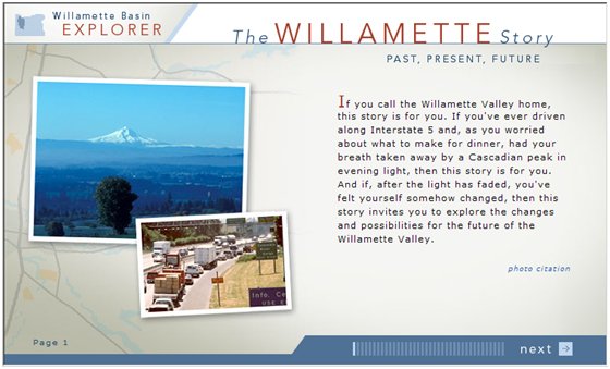
Figure 1. Example of multi-media story featured on the home page of the Willamette Basin Explorer (www.willametteexplorer.info)
The Willamette Basin Explorer features interpretative information, several multimedia stories, free GIS mapping tools, conservation reporting tools, and online maps. Access to the ScholarsArchive@OSU, our dSpace-based institutional repository, and the OSU Archives' digital photo collections in CONTENTdm enables users to access pertinent reports and scholarly materials for the Willamette Basin. Geo-reference indexing was later added to both our instance of dSpace and CONTENTdm to facilitate access to materials for particular geographies.
The success of the Willamette Basin Explorer led to the development of basin portals for Oregon's North Coast (www.northcoastexplorer.info) and Umpqua Basin (www.umpquaexplorer.info). An Oregon Explorer business plan was developed (Oregon State University Libraries and Institute for Natural Resources 2007) after these basin portals were underway. It set out to create basin portals for the 15 designated basins in Oregon. We have since realized that portal development should be based on user demand. Where there is demand, a good case can be made that the site will be used (and maintained) and a stronger case for funding portal development can be made.
In the case of the Umpqua Basin Explorer, the Partnership for the Umpqua Rivers (PUR) approached OSU Libraries with funding to develop a site encompassing their local watersheds and supporting watershed restoration decision-making. With PUR, we have completed three development phases of this basin portal. Currently basin portals for the Deschutes Basin and the Lakes Basin are under development with the support and input of the locals in each of these areas.
Topic Portals and Tool Development
After three basin portals had been launched, OSUL and INR were approached by State agencies interested in providing access to their data and information. This information was often statewide, but narrowly focused on particular natural resource issues and topics. The first public agency to approach us was the Oregon Department of Forestry after they had completed a statewide wildfire risk assessment with public involvement. The concept of digital library "topic portals" complemented our growing collection of "basin portals". In partnership with the Oregon Department of Forestry, we developed the Wildfire Risk Explorer (www.oregonexplorer.info/wildfire)--the first statewide topic portal in our evolving natural resources digital library—the Oregon Explorer.
Like our basin portals, the topic portals provide access to stories, expertise, mapping tools, reporting tools, and the documents in the ScholarsArchive. Development of each new Oregon Explorer portal has involved the creation of at least one new decision support tool and the addition of new GIS data layers to the Oregon Explorer advanced mapping tool. The Wildfire Risk Mapping tool featured on the Wildfire Risk Explorer was developed to support community wildfire protection planning throughout the State. Users can create online maps of wildfire risk in an area based on different search criteria. One of our most popular Oregon Explorer topic portal tools is the Oregon Communities Reporter featured on the Rural Communities Explorer (www.oregonexplorer.info/rural ). With this tool, users can report on up-to-date social, demographic, economic, and environmental information for communities throughout Oregon (Etuk and Bridges 2009).
Oregon Explorer--Phase 1
With the launch of the first statewide topic portal, we were well positioned to develop the full natural resources digital library we envisioned for Oregon. A successful grant application to the Oregon Watershed Enhancement Board enabled us to develop and launch the Oregon Explorer site (phase 1) within a one-year timeframe. The Oregon Explorer site provides the framework for all current and future geographic and topic portals. An important need was for a user to search across all the sites, experience a consistent "look and feel," and access a growing collection of multi-media stories, decision support tools, and geo-referenced materials.
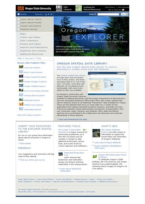
Figure 2. Oregon Explorer home page (www.oregonexplorer.info) as of 11-18-09
From the Oregon Explorer home page (see Figure 2), users can now search all of the Oregon Explorer portals, access a multimedia feature story or high profile decision support tool, browse by places (water basins, counties, or ecoregions) or topics (e.g., soils, fish, forests, invasive species, fire, endangered species, or water quality). The search feature currently relies on LibraryFind™ (http://libraryfind.org/), a tool developed at OSUL which harvests a wide variety of materials from Open Archives Initiative (OAI)-compliant sources including university libraries and federal, state, and local agency sites.
County pages were developed to integrate the various tools and content developed in each of the Oregon Explorer portals. Static "basin pages" were created (primarily as placeholders) for those basins that do not have a corresponding basin portal. The free GIS mapping tools (see Figures 3 and 4) and multi-media stories continue to be the most highly accessed digital library features. In the GIS mapping tools, layers are turned on and off by checking the boxes listed to the left of the layer names within open folders. Maps can be annotated and analyzed within the tool.
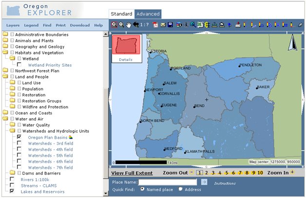
Figure 3. Example of the Oregon Explorer advanced mapping tool
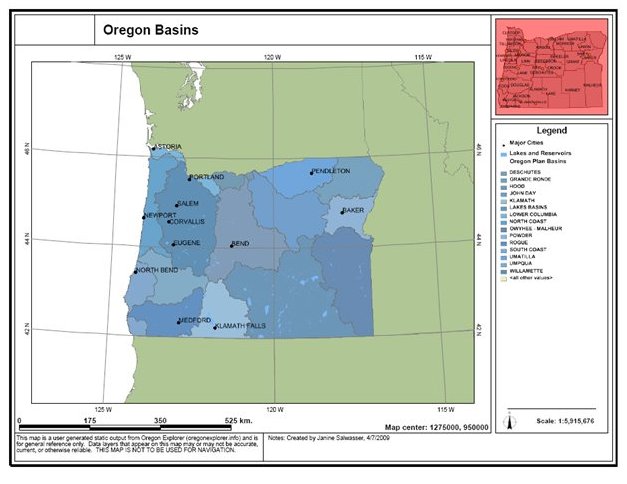
Figure 4. Output map created using the Oregon Explorer advanced mapping tool
Our usability tests have shown that users appreciate and value the Oregon Explorer's free access to GIS software, data, and metadata. Access to a high speed internet connection and a computer is all that is needed. The advanced mapping tool also enables users to download GIS data, as well as print or e-mail maps they have created.
With the launch of the Oregon Explorer, the demand for topic portals increased, and we began to develop them at a more rapid pace and at a significantly lower cost per portal. The first portal (Willamette Basin Explorer) was developed with a $500,000 grant and the topic portals have averaged $50,000 to 75,000 per portal to develop. The cost reductions are largely due to early investments in system architecture and tool construction (e.g., GIS mapping tools and visualization tools) that can be re-purposed and enhanced for new applications with significantly less programming time.
Data Portals
The Oregon Imagery Explorer was the first data portal to be created for the Oregon Explorer. The Oregon Department of Administrative Services (DAS) had acquired .5 meter color photography (vintage 2005) for the entire state and was supportive of the Oregon Explorer mission and services. DAS is the state entity that coordinates all data standards and GIS data development in the state. A partnership with DAS was formed to develop the Oregon Imagery Explorer (http://www.oregonexplorer.info/imagery). With this data portal, the imagery is stored at the State Data Center behind firewalls, and a third party contractor was hired to create the interface to access imagery (see Figure 5). This has been a very successful portal, and new statewide imagery will be uploaded as it is collected. A second Oregon Explorer data portal, the Oregon Spatial Data Library (http://spatialdata.oregonexplorer.info) developed in partnership with DAS provides access to all the spatial data including "framework" data for the State of Oregon. Framework datasets serve as "base data" for a variety of GIS applications that support important research, business, and public services. Administrative boundaries, transportation, land use, ownership, water, hazards, and wetlands are examples of framework data.
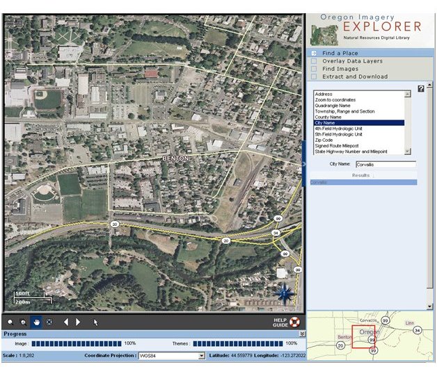
Figure 5. Example of Oregon Imagery Explorer image viewing and extraction tool (www.oregonexplorer.info/imagery )
Current State
As of November 2009, the Oregon Explorer provides users with access to three basin portals, six topic portals, and two data portals. A complete chronology of Oregon Explorer portal development is presented in Table 1.
| Portal | Public Launch | Portal Type | Partners |
Decision-support tools developed |
Willamette Basin Explorer |
June 2004 |
Basin |
OSUL, INR, University of Oregon, Defenders of Wildlife, Oregon Watershed Enhancement Board |
GIS mapping, conservation reporting tool, access to atlas content and research materials |
North Coast Explorer |
February 2005 |
Basin |
OSUL, INR, University of Oregon, Oregon Dept. of Fish & Wildlife, Oregon Dept. of Administrative Services, Oregon Dept. of Environmental Quality |
Visualization tools for salmon habitat restoration, access to watershed assessments |
Umpqua Basin Explorer |
March 2006 |
Basin |
OSUL, INR, Partnership for the Umpqua Rivers, Oregon Watershed Enhancement Board |
Visualization tools for watershed restoration, water quality, fish passage, access to bibliography |
Wildfire Risk Explorer |
October 2006 |
Topic |
OSUL, INR, Oregon Dept. of Forestry |
Visualization tools for wildfire risk mapping |
Oregon Explorer |
June 2007 |
ALL |
OSUL, INR, Oregon Watershed Enhancement Board |
Federated searching, watershed mapping and reporting tools |
Oregon Imagery Explorer |
October 2007 |
Data |
OSUL, INR, Oregon Dept. of Administrative Services |
Image viewing and extract tool, image streaming |
Land Use Explorer |
November 2007 |
Topic |
OSUL, INR, Portland State University, Oregon Community Foundation |
Visualization tools for land use decision-making |
Oregon Wildlife Explorer |
January 2008 |
Topic |
OSUL, INR, Oregon Dept. of Fish & Wildlife |
Wildlife reporting tool |
Rural Communities Explorer |
October 2008 |
Topic |
OSUL, INR, OSU Rural Studies Program, OSU Extension |
Oregon communities reporting tool |
Oregon Hazards Explorer |
June 2009 |
Topic |
OSUL, INR, Oregon Dept. of Administrative Services, Oregon Dept. of Land Conservation & Development |
Hazards reporting tool |
Oregon Wetlands Explorer |
November 2009 |
Topic |
OSUL, INR, The Wetlands Conservancy, Oregon Dept. of State Lands |
Oregon rapid wetland assessment protocol tool |
Oregon Spatial Data Library |
November 2009 |
Data |
OSUL, INR, Oregon Dept. of Administrative Services |
GIS data viewing and extract tool, data streaming |
Table 1. Chronology of Oregon Explorer portals, partners, and decision-support tools
Development of the Oregon Explorer and the associated basin, topic, and data portals has helped us towards our goal of developing a comprehensive natural resources digital library. Different partnerships have formed for the different places and topics which we believe will help to sustain the Oregon Explorer over the long-term.
Digital Library and Portal Development Process
When we developed the first digital library prototype, the Willamette Basin Explorer, we used a process that engaged users (who often were our project partners) at the onset. The portal development team included librarians, researchers, conservationists, natural resource specialists, programmers, graphic designers, and science writers. All team members also lived within the Willamette Basin. For each subsequent portal developed, we continue to bring in a diversity of talents and skills to serve on portal project development teams. For our basin portals, it is especially important to have local representation from that basin on the project team. The process used to develop portals for the Oregon Explorer is graphically presented in Figure 6.
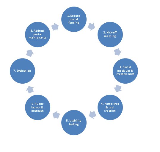
Figure 6. Schematic of digital library/portal development process
1. Secure portal funding
The first step of any portal development project is to secure new funds. The Oregon Explorer has been developed and funded incrementally over the past seven years. To date, more than $2.8 million has been invested in the development and maintenance of the site as a whole (see Figure 7).
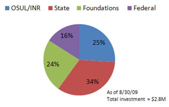
Figure 7. Oregon Explorer investments by funding category
Each portal has been developed with a different combination of public and private funds. Our portal partners often help us to identify and secure appropriate funding sources. For new ("phase 1") portals, it can take from 6 to 18 months to secure funding, whereas for enhancements to an existing portal ("phase 2" etc.), the funding can often be secured in half that time.
2. Kick-off meeting
The purpose of a "kick-off" meeting is to formally begin a portal development project with our partners and reach agreement on the specific scope of a site, especially for a phase 1 product. At this meeting, we review the "Oregon Explorer" framework and discuss portal expectations (site purpose, targeted users, priority issues, content focus, decision support tool needs, etc.). The "kick-off" meeting is also the venue for discussing specific development issues such as roles and responsibilities, timelines, milestones, and contacts. Subsequent meetings with the project team discuss portal content and tool development progress.
3. Portal mock-ups and creative briefs
Two key documents are developed from the kick-off meetings: a creative brief and a hard copy portal mock-up(s). The creative brief specifies portal objectives, target audience, key messages, navigation fields, and content for the site. A creative brief example is provided in Attachment 1. The mock-up is a hard copy design of what the portal could look like. Sometimes it is helpful to create several mock-ups for partners to review. The finalized creative brief and mock-up are used by the project technical team (web designers, programmers, and content providers) to build a beta version of the site. Creation of the mock-up begins with a standard Oregon Explorer template (see Figure 8). Slight variations to the template are allowed to accommodate the varying needs of users in different places (basins) or for different topics (natural resource issues). For example, the "feature space" might showcase a multi-media story, decision-support tool, or dataset depending upon what is considered to be the most popular feature by our partners.
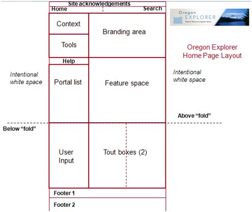
Figure 8. Oregon Explorer template for portal home page layouts
4. Portal shell and tool development
The portal mock-up and creative brief guide the development of a preliminary portal shell and associated decision-support tool(s). Creation of the portal shell is often an early milestone in a portal development project. Once project partners are able to access the shell remotely, it becomes much easier to track the progress of a portal development project. It also enables the remote uploading of content by our portal partners and subcontractors (e.g., the science writer). Much of the Oregon Explorer is built around "stories" or descriptive text that helps to provide a context for a place or natural resource issue.
In addition to the portal shell development, we concurrently develop the decision-support tool(s) that will help inform natural resource decision-making for specific places and/or topics. Beta versions of the tools are created mid-way through a portal project and presented to the portal partners. Refinements are made to the tools based on the input from the project partners and other potential users. The Oregon Explorer tools on all portals include a growing collection of free mapping, reporting, and visualization tools that help to make our natural resources digital library purposeful.
5. Usability testing
Prior to the completion of a portal and decision-support tool, usability testing is carried out to see if the portal and tool are resulting in a successful user experience. The usability testing is performed in both one-on-one and group (or "open house") venues with representatives from the targeted user groups. Results from usability testing are shared with the project's technical team to address needed refinements prior to a public launch of the portal. It is preferable to complete usability testing 4 to 6 weeks prior to a scheduled launch date.
In our creative briefs, we often identify both a soft launch and a public launch date for a particular portal. The soft launch often occurs before a specific usability test. The idea of a "soft" launch is to let a broader group of users know about the site so that they can test the site's performance prior to a full-scale public launch.
6. Public launch and outreach
The public launch of a portal is a great time for celebration. Dates are chosen that coincide with a relevant public event. Press releases, bookmarks, flyers, and email announcements are used. Often portal partners are better equipped to handle the outreach of a portal, especially at the local level. For example, our partnership with OSU Extension Service, whose mission is to provide community outreach and engagement, has been instrumental in getting more people aware of and using the Rural Communities Explorer portal and the Oregon Communities Reporter tool.
Through one of our grants, a public relations firm was hired to develop an Oregon Explorer outreach strategy. The strategy includes tasks such as contacting public relations officers for all relevant state and local agencies and journalists who cover natural resource issues so that they are informed about the Oregon Explorer and can be targeted in future portal launch activities. The inclusion of a part-time outreach coordinator was another recommendation. Future grant proposals will likely include a budget to cover this important function.
7. Evaluation
Once a portal has been publicly launched, the use of the site is evaluated through several means. Tracking the usage of an Explorer site is done using Urchin v.5 software. With this software, the number of sessions per day for the Oregon Explorer site can be tracked as a whole and the associated basin portals. For example, the Oregon Explorer usage statistics tell us that the site has increased from an average of 250 plus user sessions/day in 2007 (when it was launched) to an average of 640 plus user sessions/day in 2009. Summary reports can be generated for specified time periods identifying the most popular Oregon Explorer services and content accessed and downloaded, as well as the pathways users took to enter, navigate, or exit a site.
User feedback is solicited on the home page of each Oregon Explorer portal. In collaboration with the OSU College of Business, an online survey form is used that compiles user responses to a set of questions that can be easily modified as new portals are developed. This tool immediately informs us when a specific user is satisfied or dissatisfied with a particular portal. With this tool, specific recommendations are received on how to improve the usefulness of an Explorer portal. These recommendations are captured and often incorporated in future development phase proposals.
Focus group sessions are also used to evaluate a site and/or identify a focus for future portal development phases. Focus groups can be used to collectively identify issues and concerns associated with a particular portal and/or tool. The advantage of using focus groups is that the sharing of ideas in a group setting often results in spontaneous ideas that would not have emerged otherwise. Focus groups are more costly to conduct, and they are typically done when the prospects for funding a subsequent portal development phase are high. The needs expressed by users in a focus group session can then go directly into a proposal.
8. Address portal maintenance
Long-term maintenance of a basin, topic and/or data portal is always an important issue needing to be addressed, especially after a public launch. A commitment has been in place between INR and OSUL since the beginning to maintain the overarching Oregon Explorer site.
When we began developing portals, portal sponsorship was not a consideration, as is the case now. Each of the Explorer portals (i.e., Oregon Explorer, Oregon Wildlife Explorer, Oregon Wildfire Risk Explorer, Oregon Imagery Explorer, Rural Communities Explorer, and Umpqua Basin Explorer) that prominently display a partner's logo indicates a shared commitment to maintain the site over time.
Our first attempt to formalize specific roles and responsibilities and address long-term portal maintenance issues was with the creation of a Governance Document with the Partnership for the Umpqua Rivers for the Umpqua Basin Explorer. The Governance Document identifies key issues and proposals to address them, such as who contributes content, who vets content, roles and responsibilities for site maintenance, and guiding principles for adding new content and tools. This document (which is revisited annually) is serving us well, and it is now being used as a requirement for all future portal development projects. We are considering the use of Memorandum of Understandings or Agreements as an alternative approach for the future since they are more commonly recognized, especially by public agencies. Those portals without sponsorship (i.e., Willamette Basin Explorer, North Coast Explorer, and Land Use Explorer) do not get updated as frequently, and any new development phases are less likely to be funded.
Looking Back and to the Future
For the librarians involved, the Oregon Explorer has provided an opportunity to work on an interdisciplinary team. Were we to begin again with the benefit of hindsight we would no doubt agree that clarification of roles is important at the onset and benefits from periodic review. . Internal communications and coordination are as critical as external communications and coordination with portal partners. Librarians play an important role in the development of bibliographies for each portal, an activity which in turn serves to focus digitization and cataloging efforts. There is also a commonly articulated sense outside the library that all librarians are skilled in organizing large amounts of information. This is not an expertise that subject librarians automatically identify with as strength, and that provides a good reason to include staff from other library units in the initial stages of each portal project.
Among other lessons learned to date is the importance of documentation and planning for the staff time to address needed system changes and maintenance. Establishing a common institutional memory is not a simple matter when staff, priorities, and technologies change. In the last year, much attention has been given to documenting the initial user-level and system architecture and the needed system restructuring that will enable the Oregon Explorer to be efficiently maintained and enhanced in the future. The Oregon Explorer is currently moving towards an open-source system to improve navigation within and between portals; to enable a site that is easier to add to and to maintain; and to better enable the sharing of the Oregon Explorer technology at regional and national levels.
The process that we have employed to develop the Oregon Explorer collection of basin, topic, and data portals is one that relies on the involvement of users and long-term partnerships. There is a need to keep the existing basin, topic, and data portals of the Oregon Explorer fresh, useful and relevant to the users. As new natural resource issues emerge and become important to the people living, working, and visiting Oregon, the demand for new Oregon Explorer portals is anticipated. Climate change, renewable energy, and invasive species are a few of these important issues in need of a portal to integrate content and decision-support tools. Users have expressed a desire for more information about Oregon's special places, such as Crater Lake. Opportunities also exist to help teachers educate our future decision-makers--our youth--to understand and learn about Oregon's natural resources so they, too, can be informed and active in their local communities. Ultimately, it will be issues of available funding, high priority needs of targeted users, and long-term partnership commitments that determine how the Oregon Explorer continues to evolve over time.
Acknowledgements
We would like to thank Ku'uipo Walsh, Hal Salwasser, and the peer-reviewers of this paper for their editorial help and suggestions. Initial and ongoing development of the Oregon Explorer™ is a team effort and we are honored to speak on behalf of that team. Teams need leaders and advocates. Karyle Butcher, Gail Achterman, Jimmy Kagan, Renee Davis-Born, Tim Fiez, Marc Rempel, Ku'uipo Walsh, Kevin Johnsrude, Larry Landis, and Ruth Vondracek have filled these roles as the Oregon Explorer has developed and as it continues to evolve.
A Note About the Author
When this article was written, Janine Salwasser was the Natural Resources Digital Library Program Director for the Oregon State University Libraries.
References
Collier, Mel. 1997. Towards a General Theory of the Digital Library. Proceedings of the International Symposium on Research, Development and Practice in Digital Libraries: ISDL '97. [Online]. Available: http://www.dl.slis.tsukuba.ac.jp/ISDL97/proceedings/collier.html[October 5, 2009].
Etuk, L. and Bridges, L. M. 2009. Oregon Rural Communities Explorer. In Courtney, N., editor. Academic Library Outreach: Beyond Campus Walls (135-146). Westport, CT: Libraries Unlimited.
Oregon Progress Board. 2000. Oregon State of the Environment Report 2000. [Online]. Available: {http://oregonstate.edu/dept/eoarc/publication/2000/490} [October 8, 2009].
Oregon State University. 2009. Strategic Plan. [Online]. Available: http://oregonstate.edu/leadership/strategicplan [October 14, 2009].
[Oregon State University Libraries and Institute for Natural Resources]. 2007. Oregon Explorer Business Plan [Online]. Available: {http://oregonexplorer.info/ExternalContent/OregonExplorerBusinessPlan.pdf} [November 16, 2009].
Salwasser, J. and Murray-Rust, C. 2002. Assessing the need for a natural resources digital library. Issues in Science and Technology Librarianship 33. [Online]. Available: http://www.istl.org/02-winter/article2.html [October 8, 2009].
The Pacific Northwest Ecosystem Research Consortium. 2002. Willamette River Basin Atlas: Trajectories of Environmental and Ecological Change. Corvallis, Oregon: OSU Press. [Online]. Available: http://www.fsl.orst.edu/pnwerc/wrb/Atlas_web_compressed/PDFtoc.html [October 12, 2009]
Appendix
Example of Creative Brief for Digital Library Portal Development
| Previous | Contents | Next |
