| URLs in this document have been updated. Links enclosed in {curly brackets} have been changed. If a replacement link was located, the new URL was added and the link is active; if a new site could not be identified, the broken link was removed. |
![]()
Data Driven Program Planning for GIS Instruction
Head Map Library, Subject Librarian for Geography & Geology
University Libraries
Kent State University
Kent, Ohio
escarlet@kent.edu
Abstract
This study used both focus groups (qualitative) and survey data (quantitative) to develop and expand an instruction program for GIS services. It examined the needs and preferences faculty and graduate students have for learning about GIS applications for teaching and research. While faculty preferred in person workshops and graduate students preferred online instruction, those who responded to the survey expressed the need for more instructional outreach in GIS. The College of Public Health, Biological Sciences and Sociology expressed the most interest in GIS instruction identifying specific subjects and data sources. The study outlines next steps and instructional objects for different audiences and for discipline specific integration of GIS.
Introduction
GIS and mapping have become more and more ubiquitous in the public sphere, from constant election commentary using maps (New York Times 2010) to disaster images and crowd sourcing (Rowan University Geolab 2012) with maps. All of this exposure in the media drives the diversification of mapping interest and the research interest in generating maps from data. The broad appeal of GIS (Geographic Information Science) and mapping has worked its way through the university and into the academic environment beyond geography departments. As GIS and Map librarians, supporting this increase in interest often means introducing non-geographers to geographic concepts and tools including GIS. After a recent increase of requests for GIS consultations by non geographers, it was important to discover 1) what additional outreach and instruction is needed for GIS services on the Kent State University campus, 2) how to meet those needs and 3) which instructional methods are preferred by the constituencies.
Background
Kent State University is a large public research university with a Kent Campus population of 27,429 with undergraduate (21,351) and graduate (6,078) students (Kent State University 2013). The university offers degree programs ranging from associate to doctoral. In 2012, the GIS librarian was interested in increasing the awareness and use of GIS throughout the university. While some GIS services were offered on the Kent Campus since 2003 through the Map Library, a change in the administration and increased access to the GIS software in the main University Library presented the opportunity to increase outreach and instruction to the larger campus community. Previous GIS services included providing GIS software distribution through the campus Esri ArcGIS license, purchasing low cost GIS data sets, providing individual searches for relevant data, performing basic data processing to use with GIS software, downloading or adding data to GIS software, and locating base maps. ArcGIS is a software program produced by Esri (Environmental Systems Research Institute) that maps, models, and performs spatial statistical analysis of data (Esri 2013). The GIS librarian provided most of the GIS services by appointment or in ad hoc sessions when patrons requested them. The Map Library had housed most of the GIS services as part of its operations. By collaborating with the Head of Reference Services and the Information Services department, who manages the software and servers, the ArcGIS software was deployed in the University Library on its 120 public computers in 2011. As a result of providing additional computers with ArcGIS software, and increasing public access, the GIS librarian included software and access information on the University Library web pages, pointing users to Virtual Campus Courses as well as GIS ready data. In short, more visibility led to additional GIS questions and requests for services from non-traditional GIS departments, including the new College of Public Health.
A research project was conducted to find out who would benefit from an awareness and instructional program, where it should begin, and what kind of instructional services to offer. The Geography department on campus provides formal coursework as well as undergraduate and graduate degree programs in GIS and the library did not intend to compete with or replace that instruction. Instead, the goal was to inform and educate interested faculty and students about the role GIS could play in complementing and enriching their research. By providing formal instruction, as well as extending traditional library services such as resources for GIS data and software instruction, more users would benefit from GIS opportunities.
Literature Review
Many disciplines have been using GIS in applied research such as air pollutant concentrations (Clougherty et al. 2013), disease mapping (Liu et al. 2013), and neighborhood food availability (Hirsch & Hillier 2013) in public and environmental health. There is also a fair amount of research in land use (Isely et al. 2010), coastal erosion (Anfuso and Martinez del Pozo 2005) and species tracking (Somoldi, Carni, Ribeiro, and Podobnikar 2012). The precedent for GIS research outside Geography and Geology is well documented. As a result, assessing the service needs in a large institution is an important part of planning. Depending on the resources of the library, services can be offered in different formats for different skills. Instructional programs especially are a balance of in-person and virtual contact, providing enough online information for those who are willing to self teach and offering in person instruction to those who are not.
The implementation of GIS services in academic libraries has been discussed in case studies like these for over ten years. Sweetkind-Singer and Williams (2001) discussed the outreach necessary as part of a new GIS instruction program. They suggest one hour in person workshops as the main instructional approach for their programs; they offered the workshops at the departmental level. Houser (2006) also provided a case study identifying the key GIS activities for which users request support: "finding specific datasets, generating a map from spatial data, converting data among formats, clipping data layers, creating data, mapping tabular data," (318). Her instruction program was based on those activities and designed as a series for both basic and advanced tracks (2006, 321). She also provided on demand workshops for individual courses. Her attendees included more graduate students and staff than faculty and undergraduates. Dixon (2006) addresses the issue of collaboration in her article, noting that providing GIS assistance is just one in a long line of information mediation activities that libraries do and should perform (2006, 11). Years after implementation, there is a need for additional assessment before changing the focus of an existing program. In a follow up survey of GIS services in small academic libraries, the remaining services were workshops and seminars offered occasionally (Kinikin & Hench 2005). March (2011) conducted a study of service needs for GIS and GPS technologies to update his current GIS support program. His survey also asked respondents where they would go for GIS help, what kind of help they anticipated and what kind of assistance they would prefer. The respondents indicated an instructional preference for online workshops (2011, 166). He notes that online resources and tutorials are a large part of the future offerings at his institution because stand alone tutorials are often perceived as the easiest way to reach large numbers of users at their own pace. Indeed these studies echo the 2005 ARL SPEC Kit (Salem 13) which noted that GIS consultations, occasional workshops, and course based instructions sessions are common services offered by libraries that have GIS services. Building on this research, this study takes an existing service, assesses the awareness of GIS in nontraditional GIS departments, and looks specifically at the need for instruction and the context for expanding outreach and how that can be tailored to individual departments and audiences.
Methods
The study uses an emergent exploratory sequential design (Creswell et al. 2003), a method where the qualitative data is analyzed in the first part of the study, and is then used to develop, and explore, the study problem. The second more quantitative part of the study is designed to check the results of the first data analysis (Creswell & Plano Clark 2011). The qualitative piece of this project was the focus group. It was designed to gauge the interests and perceived needs for GIS information and instruction from different disciplines. The researcher had some anecdotal evidence about individual departmental interest in GIS and she hypothesized that the range of knowledge and experiences with GIS varied by department, and would require a corresponding variety of instructional approaches. To test these theories, invitations were sent out to any faculty who responded to an email solicitation asking about their interest in GIS. These faculty were invited to participate in one of two focus group session to address their specific interests, experience, use of geographic information and GIS. The sessions also provided an overview of the current GIS software and service offerings by the library. The focus groups sessions were recorded and transcribed for analysis.
The qualitative results were helpful to discern attitudes and comfort level of participants as well as the level of sophistication with GIS as a research and teaching tool. Working with focus groups is one way to gather qualitative data, and has been formally used since the 1960's (Kamberlis & Dimitriadis 2005) to provide insight into the subjects through interview techniques, while also allowing group discussion to inform the other participants and their responses to the prompted questions. Focus groups in libraries are also a common way to gather a variety of thoughts around a particular topic in a short amount of time. The focus groups in this study allowed the researcher to narrow her questions and to document some of the observations that had been made prior to the study. The process of adjusting the survey and focus group questions based on feedback was:
- Focus group question development
- Intercoder agreement consultation
- Focus group questions finalized
- Focus group sessions
- Focus group feedback and analysis
- Survey question development
- Intercoder agreement consultation
- Survey questions finalized
- Survey sent to participants
The focus groups took place on two different days with a total of eight participants, two graduate students, and six faculty members. Each session was recorded for transcription and notes were taken by both moderators. The recordings and notes were transcribed and analyzed. The participants were from the departments of Architecture and Environmental Design, Justice Studies, Public Health, and Sociology. Each discussion topic was addressed to the group, and then follow up questions were posed to those group members who had not yet expressed an opinion. The focus group prompts were:
- How often/ do you use maps and geocoded (geographically referenced) data
- How often/ do you locate maps and geocoded data
- How often/ do you use an online GIS to make customized maps (e.g. National Map, or Social Explorer)
- How often/ do you use a desktop GIS to make simple maps from data (ArcGIS. ArcView, ArcExplorer)
- How often/ do you require/look for this kind of information
- What are your preferences for learning about how to find maps and geocoded data
- What are your preferences for learning to use online or desktop GIS tools
- What are your areas of interest using GIS, subject and geographic interest areas for using GIS
These topics were developed based on questions the GIS librarian had used before in consultations with new GIS users, and in preparation for other instruction sessions. They were refined with a library colleague who had limited knowledge of GIS and its applications to ensure clarity for participants unfamiliar with GIS. This colleague also assisted in note taking and transcriptions of the focus group sessions.
The resulting focus group participation was not broad enough to generalize about the full range of experience and needs on the campus. Ideal focus groups contain 5-8 people per session, and our groups did not meet that standard. Instead, based on the analysis of the data from the focus groups, a more detailed web based anonymous survey using Qualtrics software was distributed to reach a larger sample population (see Appendix 1 for survey instrument). A listing of faculty and teaching graduate students was made from disciplines including: Public Health, Nursing, Environmental Health, Biological Sciences, Geology, Architecture, Sociology and Anthropology. A total of 547 possible participants were identified for the survey distribution. The results were analyzed using both the Qualtrics tools for variance, and cross tabulations for statistical significance. In addition, results were input into IBM SPSS software for additional cross tabulations and data manipulation.
Results
Focus group participants were asked a series of questions about their use of geographic information and current GIS services (listed above). Participants were from a variety of departments including Architecture and Environmental Design, Public Health, Justice Studies, and Sociology. They also had a range of experience and familiarity with geographic data and GIS, from consistent use of ArcGIS to an interest in mapping data from standardized surveys. Participants who had more experience with GIS were looking for more resources and tools for GIS and less instruction. Participants with less experience indicated a desire for a more in-depth description of GIS applications and benefits, or for instruction for themselves and their students. Some had been using GIS for a while, some just had an interest, and others wanted to know how it might be integrated into their research and class work. One focus group member thought that GIS could mean any digital map or data that is needed for research.
The types of instruction identified as useful to participants included, brief introductory exercises for students in a course; individual instruction for basic ArcGIS software for faculty; introduction to the uses of GIS, and introductory presentations for departments. In addition, participants identified several datasets that they would like to use with GIS tools. Many identified web tutorials or written instructions as important supporting materials.
Participants also discussed the use of both local and national data, some of which are geocoded for use with GIS and some are not. (Geocoding is a term used for associating data points with a geographic location such as a zip code, address, Census block group, county, or state.) They talked about collaboration between researchers using GIS and having the library as a hub for that collaboration. When asked if they would participate in a listserv both for new products and services and as a place to exchange research ideas relating to GIS, most agreed this would be helpful.
The focus group discussions provided guidance to the types of questions included in the web based survey. The web based survey was a way to reach a larger audience with fewer time and scheduling demands than an in person meeting, to ask a variety of questions, and to allow participants to consider their answers in greater depth. The survey was intended to answer the following questions:
- What type of instruction do potential GIS users want?
- What topics are of interest to potential users?
- What kind of support issues might there be for new GIS users?
The web-based survey was sent out to faculty and teaching graduate students (n=547 persons) in the departments who indicated interest in the previous solicitation. Eighty-five responses were received for a good completion rate of 16%. Responses were received from 54 faculty, 30 graduate students, and one faculty administrator. The respondents represented at least one response from each discipline targeted within the survey. The home departments and the percentage of the respondents are listed (N=85):
| Unknown | 4% |
| Architecture / Urban Design | 5% |
| Anthropology | 4% |
| Nursing | 9% |
| Geology | 13% |
| Public Health | 15% |
| Sociology | 19% |
| Biological Sciences | 29% |
| Total (due to rounding does not add to 100) | |
When asked about their prior experience with GIS, 68% were familiar with GIS at the time of the survey and 45% had used GIS tools previously. Sixty-seven percent of GIS users had utilized these tools for research.
What type of instruction do potential GIS users want?
Respondents indicated that they saw a need for GIS instruction, agreeing at 86% that there is a need for training on the use and implementation of GIS technology on campus. Survey respondents also ranked types of instruction in order of preference, marking occasional drop-in workshops at the top of the list. Web tutorials and personal appointments came in second and third respectively. Looking at the preferences of two different groups; 48% of faculty selected occasional workshops and then preferred web tutorials; written instructions; on demand workshop for a department or school; and on demand workshop for classes respectively. Graduate students preferred occasional workshops at 35%, on demand workshops for department or school; written instructions; personal appointments; on demand workshops for class; and web tutorials respectively.
What topics interest potential GIS users?
Survey respondents were asked which topics were of interest to potential GIS users. Ranking the topics overall: a GIS basics workshop; using statistical analysis with mapped data, and mapping individual data were chosen in order of preference. Faculty listed instructional topics in a similar ranked order, while graduate students preferred using statistical analysis with mapped data and mapping their own data slightly over GIS basics workshops. With respect to basic GIS instruction, 74% of all respondents agreed that their research would benefit from a GIS basics workshop; 65% said that teaching and instruction would benefit from a GIS basics workshop; 70% agreed their students would benefit from a GIS basics workshop.
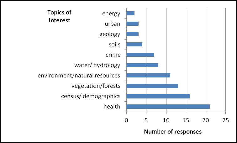
Preparing workshops, tutorials and web pages for instruction is always more meaningful when using relevant "point of need" topics. Respondents were asked to identify their top three topical areas of interest for GIS. The topics and datasets were analyzed and grouped into the categories shown in Figure 1.
What kind of support might be needed?
When asked which specific datasets that they would like to use for potential GIS work, respondents named 31 datasets. These datasets were reviewed to see if they had a geographic component that could be easily joined with a geographic reference point to use in a GIS. They are listed below in Table 1. As many popular datasets may or may not be GIS ready, information on how to check for georeferencing in datasets is a must for librarians.
| Table 1. Named Datasets | ||
|---|---|---|
| Dataset | Count | GIS ready? |
| Census | 11 | Y |
| BRFSS- Behavioral Risk Factors Survey | 7 | Y |
| Medical Expenditure Panel Survey | 4 | N |
| Add Health- National Longitudinal Study of Adolescent Health | 2 | N |
| GSS- General Social Survey | 2 | N |
| NHANES- National Health and Nutrition Examination Survey | 2 | N |
| Pew | 2 | Some/varies |
| UCR-Uniform Crime Reports | 1 | N |
Discussion
The solicitations for both focus groups and the GIS Services survey served as inadvertent marketing for GIS. Both the focus group sessions as well as the survey distribution raised the profile of the GIS librarian among potential GIS users and she received several calls for GIS consultations and instruction specifically referring to them as prompting the call. This kind of feedback indicated that while some outreach was going on regarding GIS services from the Map Library, many more faculty were not sure who to go to on campus for basic information and instruction. Also, by discussing the current software and training available, the librarian made critical points of contact for future service opportunities.
The focus group solicitations produced an unexpected result, faculty who were interested in GIS may or may not have participated in the focus group invitations, but they noted the librarian who was connected with GIS. While this may not have been the primary goal of the sessions, it is an important outcome for library services in this area. In addition to the focus group, the survey distribution also brought the GIS librarian to the attention of many potential GIS users. The GIS librarian received several calls for GIS consultations and instruction specifically referring to the survey or the focus group invitations as prompting the call.
Instructional Opportunities
The library is in a unique position to provide instruction on how GIS can augment or become a larger part of research projects by providing both ArcGIS software and Virtual Campus courses for those faculty and students that are interested. The GIS librarian can foster relationships that can benefit faculty with future GIS related projects. As part of a subject librarian program, many faculty and departments already have a relationship with their subject librarian that can be built upon. They are familiar with librarian- faculty collaborations for resources and instruction. Including GIS instruction as another piece of the library's services can increase the resources available to them.
Fifty percent of survey respondents had not used GIS before, and 34% specified they needed training to use it, and several others indicated that they were not yet sure of its applications. The survey results show that 70% of respondents overall, saw a need for GIS instruction on campus. Whether or not users are familiar with GIS or have used GIS tools, they agree that there is a need for additional instruction. Extrapolating the interest in GIS from the survey to the faculty in the departments who were targeted, a large group of faculty and graduate students may be interested in learning about GIS and its applications. Faculty and graduate students had different preferences for modes of GIS instruction. Taking these into account, different sessions can be developed to meet with different constituencies. Faculty meetings with departments and occasional workshops can be approached with those preferences in mind.
Eighty percent of those who had used GIS tools before used Esri Arc products. It is not clear if they had used the Esri product because it has been part of the university educational license for over ten years or because it is a dominant software program in the industry. When asked what other GIS tools they had used, AutoCad, Geoda, PCI Geomatica, GRASS, and Gimp were mentioned. March also found that most of the GIS tool users utilized Esri Arc software (2011 160). Users who have experience with the product would benefit from additional or refresher instruction in the ArcGIS products as well as instruction or tutorials about file conversion, compatible programs, and ArcGIS plug-ins. For the 68% who are already use GIS tools, advanced instruction and enhancement programs would also be beneficial.
In the cross tabulations of those who had used GIS previously and preferences for instruction, occasional workshops and web tutorials were the most distinct preferences. This group also preferred mapping individual data and statistical analysis. These preferences provide some instructional objectives for the advanced instruction sessions mentioned above. Among those who had not used GIS previously, the preferences for instruction were GIS basics and occasional workshops. The preference for topics was not definitive in this group, but they did list statistical analysis of mapped data a little ahead of the other choices. The GIS Basics workshop should include a mention of statistical tools and some of their applications as part of its objectives. March found a preference for online workshops in his study for GIS basics (2011 166) and Sweetkind-Singer & Williams (2001) and Houser (2006) both provided occasional workshops as part of their instruction program. Kinikin & Hench (2005) found these to be common instructional techniques as well in their studies of smaller academic library offerings.
The sociology and public health departments preferred occasional workshops over the other instructional formats while Biological Sciences preferred occasional workshops and web tutorials equally over the other formats. Geology preferred personal appointments and occasional workshops over the other choices. Nursing, archeology and anthropology departments did not exhibit a distinct preference for instructional methods, but they were also less fully represented in the respondent pool. Because the participation of individual departments was less representative over all in the survey, it is not possible to generalize about those preferences too far at the departmental level. This does provide librarians with a sample of how different the instructional preferences can be based on prior experience and knowledge of GIS.
Potential Users of GIS (Support Issues)
Health topics lead all others when users were asked how they wanted to apply GIS. The GIS librarian had a particular interest in the response rate for the new College of Public Health. The college had just added new programs jointly with the department of Biology in Biostatistics and Epidemiology and the enrollments had increased each semester. Surprisingly, the largest response was from the department of Biological Sciences. In the past, the GIS Librarian had made small outreach efforts to the College of Public Health and had had requests for additional visits, but the response rate does suggest a significant outreach effort should be made to the department of Biological Sciences as well.
While health topics may include parts of the Biological Sciences department studying epidemiology, the other focus of the department is ecology. Data provided by national government agencies like the U.S. Geological Survey and the Environmental Protection Agency as well as others are often distributed as geocoded datasets. The applications in the field are also plentiful (Girard et al. 2013; Isely et al. 2010; Parks et al. 2013; Schirpke et al. 2013), but there is little about how to begin outreach to faculty and researchers who have less GIS knowledge or exposure and or who have not yet added a GIS component to their own teaching and research. From the literature of biology and ecology education (Hall & Post 2008; Hanley et al. 2012; Mitzman et al. 2011; Post et al. 2006; Prisley & Luebbering 2011), some instructors have begun applying GIS as part of a course project, or as a field learning exercise. That being said, programmatic integration of GIS and specific training requirements are not discussed as part of the biology or the ecology education curriculum. Based on the amount of interest expressed from Biological Sciences, they may well benefit from additional outreach, related resources and instruction. Another explanation for this result may also be joint appointments for faculty in both Biology and Public Health, or the emphasis on ecology and natural resources in the Biology department.
In the Sociology department, also a large respondent group, many of the responses cited the specialization of Justice Studies where crime mapping has become increasingly popular. The field of Sociology also has a history of using social data such as the U.S. Decentennial Census which works well with GIS systems and analysis. As with some of the public health datasets, the desire for geospatial analysis can be greater than the availability of the data. One of the participants in the focus group sessions also expressed a particular interest in crime mapping. In Table 1, many noted national datasets are not GIS ready, geocoded. That is, they do not have a consistent geographic reference that can be assigned to each respondent and then used in a mapping or geostatistical program. Crime or victim locations and other similar data are often considered sensitive and may only be available on a special request basis. Similarly, some of the restricted data from studies such as NHANES (National Health and Nutrition Examination Survey) may contain geographic references, but that information was not available in the dataset description or on the website (Centers for Disease Control & Prevention 2012). By contrast, many earth science datasets are already geocoded and do not contain sensitive personal data. Those datasets are easily adapted for a GIS. This fact may be part of the reason that earth sciences researchers have adopted GIS earlier than others.
Several studies have explored the idea of integrating GIS at the programmatic level for public health education with pilot projects using portals and module instruction (Robinson & MacEachren 2011), in the community college setting especially for working professionals (Jeffery & Alvarez 2010), and for public health nursing education (Riner et al. 2004). Some studies even do needs assessment for specific programs to determine what kind of technological and theoretical skills are needed before integrating GIS into the curriculum (Hopfer et al. 2009). This seems to be a growing trend and these departments should be targeted for GIS outreach and instructional opportunities. Survey respondents also cited environment and natural resources topics as important areas of interest in applying GIS (See Figure 1). Many of these studies have not involved subject librarians or GIS librarians in the process of instruction or in a GIS awareness campaign. According to the data in this study, Biology and Public Health faculty as well as Sociology faculty seem the most likely candidates for targeted instruction and information. Part of a GIS awareness campaign would need to include the concept of geocoding and its importance at the design stage of research projects and grants. Including these elements in the data collection stage would provide researchers with the possibility for GIS mapping and statistical analysis in the project, whether or not it is the original focus. In addition, researchers using sensitive data would know to request the location information as part of grant and Institutional Review Board applications.
Conclusion
Increasing instruction and outreach for GIS at the interim stage of a program can be more targeted than the initial one. Individual departmental needs and skill sets can be addresses as well as instructional preferences and objectives. Faculty prefer in person instruction more often than graduate students, and overall, a combination of both tools is likely to be necessary. Instruction preferences differ not just based on discipline, but on the researchers' roles and comfort with virtual instruction. Librarians can provide faculty with several ways to apply GIS to existing and future projects by reaching out to individual departments with knowledge of both existing relevant datasets as well as research design requirements for use in GIS. Many faculty have been using national datasets for years, but are often unaware of the GIS potential.
Several steps for approaching potential GIS users have emerged from this research. The first is setting up meetings with the Biological Sciences, Sociology, and Public Health departments about opportunities for GIS integration and library services related to GIS. These might include PowerPoint presentations, departmental discussions or email solicitations, depending on the needs of the department. The faculty in this study preferred in person instruction, so the presentations might be better received in person as well. In addition, materials can be made available on the library's website for anyone else who has GIS needs, including the graduate students who tended to prefer online instruction. The second step is to approach these departments with the literature of applied GIS usage in their discipline, and having a list of which common datasets are georeferenced, and which might be needed to be geocoded in order to work with them, would be good preparation. A third step, creating a menu of instructional opportunities or tracks for both faculty and graduate students, and including some virtual training options provides a scaffolding of instruction that can help assuage any fears new users may have about jumping into a GIS project without adequate support. A last step (and a bit of assessment) would be to try to determine the amount of traffic instruction sessions would draw based on the in person meetings and to schedule them accordingly. Popular sessions could be recorded and posted for virtual users and those who could not make the in person sessions.
As a follow up to both the focus group participants and the survey respondents, a listserv for GIS users, or those interested in GIS, should be created and administered by the GIS librarian. Occasionally pushing new products or features of the current software options and asking for feedback for potential new products could help engage the community. In addition, encouraging collaboration among group members by allowing them to post to the listserv would also serve a need expressed by the study participants. Continued assessment of the needs on campus and moving the level of support to the advanced level of users will always be necessary at the programmatic level.
Special acknowledgements: I would like to acknowledge many hours of "intercoder agreement" sessions with Christina Ughrin without whom this project could not have been a success.
Institutional Review Board (IRB) for research involving human subjects approval was sought and received for both the focus group questions and the online survey.
References
Anfuso A., Martinez del Pozo, J.A. 2005. Towards management of coastal erosion problems and human structure impacts using GIS tools: ase study in Ragusa Province, Southern Sicily, Italy. Environmental Geology [Internet] [cited 2013 Feb];48(4/5):646-659. Available from: http://link.springer.com/article/10.1007/s00254-005-1322-2. DOI: 10.1007/s00254-005-1322-2
Clougherty J.E., Kheirbek, I., Eisl, H.M., Ross, Z., Pezeshki, G., Gorczynksi, J.E., Johnson, S., Markowitz, S., Kass, D., and Matte. T. 2013. Intra-urban spatial variability in wintertime street-level concentrations of multiple combustion-related air pollutants: The New York City Community Air Survey (NYCCAS). Journal of Exposure Science & Environmental Epidemiology. 2013 Jan 30 prepub. Available from: http://www.nature.com/jes/journal/vaop/ncurrent/full/jes2012125a.html
Creswell, J.W., Plano Clark, V.L., Gutmann, M.L., and Hanson, W.E. 2003. Advanced mixed methods research designs. In: Abbas, T. & Teddlie, C. editors. Handbook of Mixed Methods in Social & Behavioral Research. Thousand Oaks (CA): Sage Publications. p. 209-40.
Creswell, J.W. and Plano Clark, V.L. 2011. Designing and Conducting Mixed Methods Research. 2nd ed. Washington (DC): Sage Publications. p. 122-23.
Dixon, J.B. 2006. Essential collaboration: GIS and the academic library. Journal of Map and Geography Libraries. [Internet]. [cited 2011 Oct]; 2(2):5-20. Available from: http://www.tandfonline.com/doi/pdf/10.1300/J230v02n02_02. DOI: 10.1300/J230v02n02_02
ArcGIS Desktop. 2012. [Internet] [updated 2012 Nov 27]. Esri. [Cited 2013 Jan 6]. Available from: http://www.esri.com/software/arcgis/arcgis-for-desktop
Girard, T., Bork, E., Neilsen, S., and Alexander, M. 2013. Landscape-scale factors affecting feral horse habitat use during summer within the Rocky Mountain foothills. Environmental Management [Internet]. [Cited 2013 Feb 19]; 51(2): 435-447. DOI: 10.1007/s00267-012-9987-2
Hall, S.T. and Post, C.J. 2008. Advanced GIS exercise: Estimating beach and dune erosion in coastal South Carolina. Journal of Natural Resources and Life Sciences Education 37:49-52. Available from: {http://search.proquest.com/docview/194528372?pq-origsite=gscholar}
Hanley, C.D., Davis, H.B., and Davey, B.T. 2012. The impact of professional development in natural resources investigations using geospatial technologies. Journal of Natural Resources and Life Sciences Education 41(1): 68-78.
Hirsch, J.A. and Hillier, A. 2013. Exploring the role of the food environment on food shopping patterns in Philadelphia, PA, USA: A semiquantitative comparison of two matched neighborhood groups. International Journal of Environmental Research and Public Health [Internet]. [Cited 2013 Feb 6]; 10(1), 295-313. Available from: http://www.mdpi.com/1660-4601/10/1/295
Hopfer, S., Chadwick, A.E., Parrott, R.L., Ghetian, C.B., and Lengerich, E.J. 2009. Assessment of training needs and preferences for geographic information systems (GIS) mapping in state comprehensive cancer-control programs. Health Promotion Practice. [Internet]. [Cited 2012 Dec 8]; 10(4): 579-587. Available from: {http://journals.sagepub.com/doi/abs/10.1177/1524839907309047}
Houser, R. 2006. Building a library GIS service from the ground up. Library Trends. [Internet]. [Cited 2011 Oct]; 55(2): 315-326. Available from: http://web.ebscohost.com/ehost/pdfviewer/pdfviewer?sid=894ca4ec-b4bb-4ad7-b5a5-3431a593458f%40sessionmgr13&vid=4&hid=22
Isely, E.S., Isely, P., Seedang, S., Mulder, K., Thompson, K., and Steinman, A.D. 2010. Addressing the information gaps associated with valuing green infrastructure in west Michigan: Integrated Valuation of Ecosystem Services Tool (INVEST). Journal of Great Lakes Research. [Internet]. [cited 2013 Feb 19]; 36 (3):448-457. DOI:10.1016/j.jglr.2010.04.003
Jeffery, S. and Alvarez, J. 2010. Mapping the future today: The community college of Baltimore County geospatial applications program. Community College Journal of Research and Practice. 34(11): 945-47.
Kamberelis, G. and Dimitriadis, G. 2005. Focus groups: Strategic articulations of pedagogy, politics, and inquiry. In: Denzin, N.K. and Lincoln, Y.S. eds. Sage Handbook of Qualitative Research 3rd ed. Thousand Oaks, CA: Sage Publications, p. 887-907.
Kent State University. 2013. Fifteenth Day Enrollment Statistics: Kent Campus Spring 2013. [Internet]. [Cited Feb 18, 2013]. Available from: {https://web-beta.archive.org/web/20131221044047/http://www2.kent.edu/rpie/enrollment/index.cfm}
Kinikin, J. and Hench, K. 2005. Follow-up survey of GIS at smaller academic libraries. Issues in Science and Technology Librarianship [Internet]. [Cited 2013 Feb 19]; 43 (Summer). Available from: http://www.istl.org/05-summer/article1.html
Lui, C., Liu, Q., Lin, H., Xin, B. and Nie, J. 2013. Spatial analysis of Dengue Fever in Guangdong province, China 2001-2006. Asia Pacific Journal of Public Health [Internet]. [Cited 2013 Feb 6]: 2013 Jan 22 prepub. Available from: http://aph.sagepub.com/content/early/2013/01/17/1010539512472356.full.pdf+html
March, G.M. 2011. Surveying campus GIS and GPS users to determine role and level of library services. Journal of Map and Geography Libraries [Internet]. [Cited 2011 Oct]; 2(2): 5-20. Available from: http://www.tandfonline.com/doi/pdf/10.1080/15420353.2011.566838
Mitzman, S., Snyder, L.U., Schulze, D.G., Owens, P.R., and Bracke, M.S. 2011. The pilot study of integrating spatial educational experiences (Isee) in an undergradual crop production course. Journal of Natural Resources and Life Sciences Education 40:91-101.
National Health and Nutrition Examination Survey (NHANES). 2012. Questionnaires, datasets, and related documentation. [Internet] [updated 2012 June 19]. Washington, D. C.: Centers for Disease Control and Prevention, CDC.; [Cited 2012 Dec 15]. Available from: http://www.cdc.gov/nchs/nhanes/nhanes_questionnaires.htm
New York Times. 2010. House map. [Internet]. [Accessed Oct 6, 2012]. Available from: http://elections.nytimes.com/2010/results/house
Parks, S., McKelvey, K., and Schwartz, M. 2013. Effects of weighting schemes on the identification of wildlife corridors generated with least-cost methods. Conservation Biology [Internet]. [Cited 2013 Feb 19]; 27(1): 145-154. DOI:10.1111/j.1523-1739.2012.01929.x
Post, C.J., Goddard, M.A., Mikhailova, E.A., and Hall, S.T. 2006. Advanced GIS exercise: Predicting rain fallerosivity index using regression analysis. Journal of Natural Resources and Life Sciences Education 35: 113-117.
Prisley, S.P. and Luebbering, C. 2011. Uncertainty exposed: A field lab exercise where GIS meets the real world. Journal of Natural Resources and Life Sciences Education 40:144-149.
Riner, M.E., Cunningham, C., and Johnson, A. 2004. Public health education and practice using geographic information system technology. Public Health Nursing [Internet]. [Cited 2012 Dec 8]; 21(1): 57-65. DOI:10.1111/j.1525-1446.2004.21108.x
Robinson, A.C. and MacEachren, A.M. 2011. Designing a web-based learning portal for geographic visualization and analysis in public health. Health Informatics Journal [Internet]. [cited 2012 Dec 8]; 17(3): 191-208. Available from: {http://journals.sagepub.com/doi/full/10.1177/1460458211409718}
Rowan GeoLab. 2012. Hurricane Sandy Crowdsourcing Tools & GIS Resources. Rowan University. [Internet]. [Last updated 2012 Nov 12]. Available from: http://gis.rowan.edu/projects/sandy/
Schirpke, U., Tasser, E., and Tappeiner, U. 2013. Predicting scenic beauty of mountain regions. Landscape & Urban Planning [Internet]. [cited 2013 Feb 19]; 111(March): 1-12. DOI:10.1016/j.landurbplan.2012.11.010
Somodi, I., Carni, A., Ribeiro, D., and Podobnikar, T. 2012. Recognition of the invasive species Robinia pseudacacia from combined remote sensing and GIS sources. Biological Conservation [Internet].[Cited 2013 Feb];150(1): 59-67. DOI:10.1016/j.biocon.2012.02.014
Sweetkind-Singer, J. and Williams, M. 2001. Supporting the information needs of geographic information systems (GIS) users in an academic library. Science & Technology Libraries [Internet]. [Cited 2011 Oct]; 21 (3-4): 175-190, p.183-185. Available from: http://www.tandfonline.com/doi/pdf/10.1300/J122v21n03_11
Salem, J.A. 2005. Spatial Data Collections and Services. Washington (D.C.): Association of Research Libraries Office of Leadership and Management Services. ARL SPEC Kit 291. [Internet]. [Cited 8/6/13]. Available from: http://babel.hathitrust.org/cgi/pt?id=mdp.39015062490811;view=1up;seq=5
| Previous | Contents | Next |
